Source page: McKinsey & Company
Commentary
Land squeeze
Renewable energy | Sustainability | Climate change
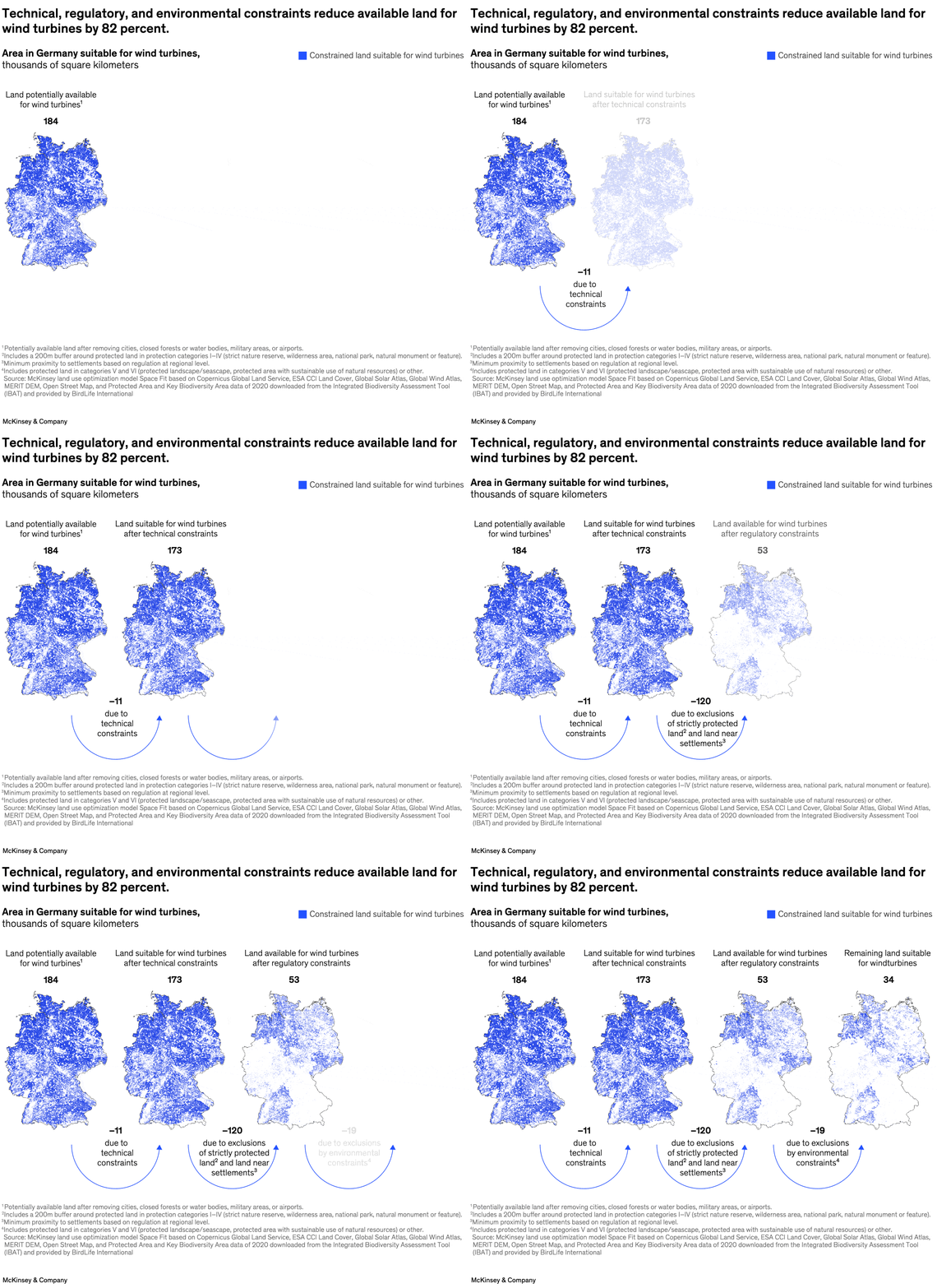
June 21, 2023 – Meeting the European Union’s goal of achieving net zero by 2050 will require the number of solar- and wind-power installations to increase threefold by 2030. Among the greatest challenges are the difficulty of finding suitable land for deployment and the barriers created by strict regulations on land use. Partner Raffael Winter and colleagues find that technical, regulatory, and environmental constraints reduce available land for wind projects in Germany by 82 percent, with almost 60 percent of the restrictions caused by regulatory rules about proximity to populated areas.
To read the article, see “Land: A crucial resource for the energy transition,” May 16, 2023.
customizer here
Visual form
Map-plus-callout land-constraint graphic.
Layout / body structure
The chart places a Germany map on the left beneath a headline callout, while the right side is mostly reserved for the legend and the visual emphasis created by the constrained-land shading.
What is being compared
It compares land in Germany that is potentially available for wind turbines with the much smaller share that remains suitable after technical, regulatory, and environmental constraints are applied.
Measurement system
The main quantity is area in thousands of square kilometers, and the title states the resulting percentage reduction after constraints are imposed.
Visible structure inside the graphic
A large numeric callout above the map marks the potentially available land, the map itself is shaded to show the constrained subset suitable for wind turbines, and the footnotes underneath spell out the layers of exclusions used in the calculation.
Main takeaway from the visual
The map is built to show how dramatically the potential footprint shrinks once constraints are applied, which is why the constrained shading occupies only a fraction of the land implied by the starting callout.
Key standout values or extremes
The headline gives the reduction as 82 percent, and the callout above the map marks 184 thousand square kilometers as the starting pool of potentially available land before those constraints are layered in.
Controls / sequence, when applicable
This is a static chart image with no in-chart controls to operate.
Companion media, when applicable
There is no separate companion audio or video; the chart image is the full visual on this page.